What Causes Waterlogging on Agricultural Land?
Waterlogging happens when water enters the soil profile faster than it can move through or out of it. In tropical Southeast Asia, three forces typically combine to push fields past that threshold.
Soil structure and texture. Clay-dominant subsoils have low infiltration rates and hold water tightly between particles.
Key mechanisms that cause waterlogging:
- Compaction (machinery, livestock, traffic when wet) collapses macropores and infiltration drops sharply.
- Surface sealing/crusting (common in silty soils after heavy rain) forms a thin, dense layer that blocks water entry.
- Layering differences (e.g., sand over clay) create a perched water table – water accumulates above the finer layer because it can’t move down fast enough.
Topography and elevation. Landscape position strongly influences where water accumulates:
- Low-lying areas / depressions lead to natural collection points for runoff and subsurface flow.
- Flat terrain leads to slow lateral movement of water; even small rainfall events can cause ponding.
- Slopes are generally better drained, but can still become waterlogged at the toe of the slope where water accumulates.
Elevation relative to the water table:
- In areas with a high water table, low elevations are more prone to saturation from below, not just from rainfall.
- Coastal or river-adjacent land often experiences seasonal water table rise, worsening waterlogging risk.
Micro-topography matters more than most people expect:
- Small undulations (even a few centimeters) can create persistent wet spots.
- Wheel ruts or poorly leveled fields act as mini drainage traps.
Water movement pathways:
- Water flows from higher to lower ground both on the surface and within the soil profile.
- Subsurface lateral flow can cause waterlogging in areas that didn’t receive much direct rainfall.
Rainfall intensity. It’s not just how much rain falls—but how fast it falls.
Infiltration vs rainfall intensity:
- Soil has a maximum rate at which it can absorb water (infiltration rate).
- When rainfall intensity exceeds this rate runoff + surface ponding occurs.
High-intensity tropical storms (common in Southeast Asia):
- Deliver large volumes of water in a short time
- Overwhelm even well-drained soils
- Increase risk of surface sealing, especially on bare soil
Duration matters too:
- Short, intense storms causes more runoff and temporary ponding
- Long, moderate rain cause for deeper saturation and rising water tables
Cumulative effects:
- Repeated rainfall events with little drying time lead to progressive saturation
- Even good soils will waterlog if they never get a chance to drain
Interaction with soil and topography:
- Clay soils + high-intensity rain = immediate ponding
- Flat land + prolonged rain = slow drainage and extended waterlogging
- Slopes + intense rain = runoff (erosion risk), but waterlogging at lower points
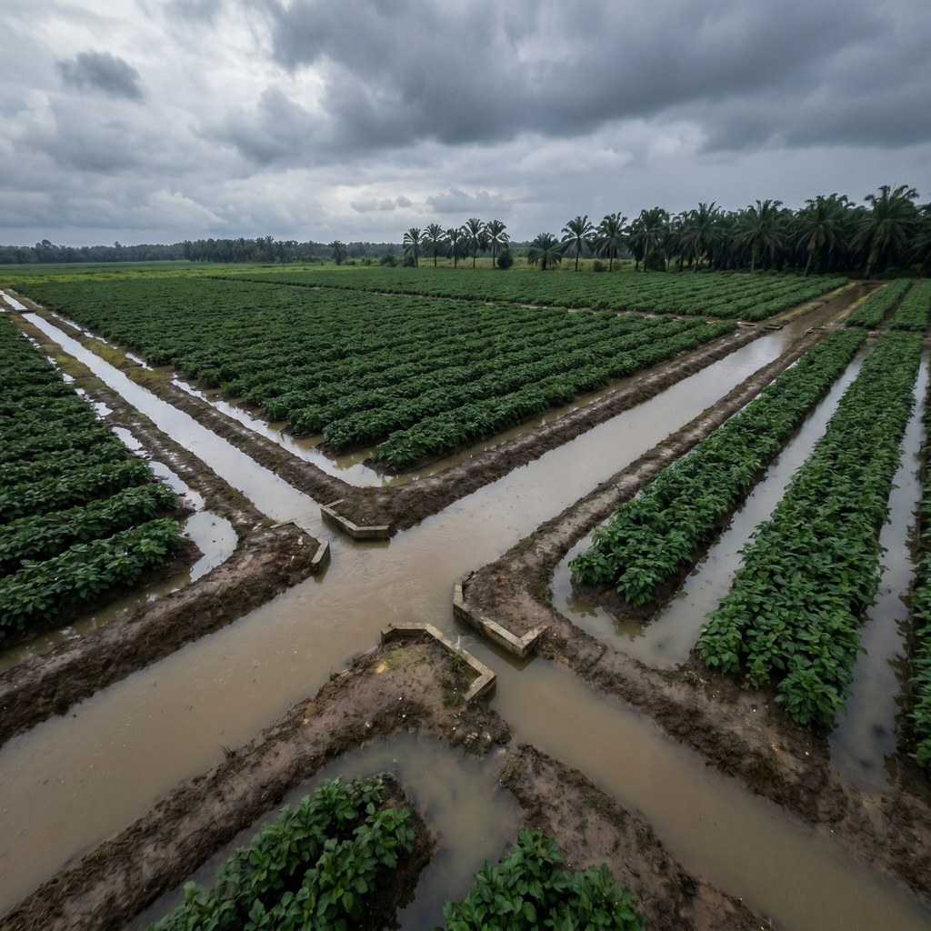
How Do Surface and Subsurface Drainage Systems Differ?
A drainage strategy almost always pairs both approaches because each handles a different problem.
Surface drainage moves water off the field before it has time to soak in. Land grading, shallow grassed waterways, contour furrows, and field-edge collector ditches direct runoff toward outlets. Surface systems are critical for handling high-intensity rainfall and for sites with low-permeability topsoils where infiltration cannot keep up. They are usually the first line of defence and are often less costly to install than subsurface options.
Subsurface drainage removes water that has already entered the soil profile. Perforated drainage pipes laid below the rootzone, mole drains pulled through suitable heavy clays, and gravel-filled French drains all work by giving infiltrated water a faster path to a controlled outlet. Subsurface systems help lower the water table during prolonged wet spells and reduce the time the rootzone stays saturated.
Many productive sites benefit from a combination of both. Surface drainage handles the headline storm event. Subsurface drainage handles the slow-release water that lingers in the profile afterward. Designed together, they help maintain aeration through wet periods, not just during rainfall.
Why Do Tropical Climates in Southeast Asia Demand Site-Specific Drainage Design?
Design guidance developed for temperate zones often needs adjustment for tropical conditions. Pipe spacing tables, ditch capacities, and outlet sizing assumptions all need recalibrating for monsoonal rainfall patterns and warm-soil hydrology.
Pipe spacing often needs to be closer where peak inflow rates are higher in tropical storms. Outlets should be sized with short-duration, high-intensity storm flows in mind, not only long-term averages. Materials must tolerate prolonged saturation, biological growth, and root intrusion under year-round warm temperatures.
Site-specific assessment tends to matter more here than in cooler climates. A topographic survey, soil profile description, infiltration testing, and water table monitoring across a full wet season give you the data to design a system that fits the site rather than a generic template.
Without that grounding, drainage projects can fail quietly. Pipes silt up, ditches under-perform during actual storm events, and the field may revert to previous drainage problems over time.
How Do You Build a Drainage Programme That Survives Monsoon Conditions?
Monsoon-Resilient Drainage Programme (Plantation Agriculture)
- Design for peak rainfall
- Size drains for intense storm events, not averages
- Ensure mainlines and outlets handle surge flow
- Layered drainage approach
- Surface: field shaping, drains, and collection channels
- Subsurface: pipe drains or field drains (where needed)
- Profile: improve infiltration through soil management
- Prioritise outfall efficiency
- Keep discharge points clear and lower than field level
- Prevent backflow during heavy rain
- Manage high water tables
- Use deeper collector drains in low-lying areas
- Consider raised beds or planting rows where necessary
- Maintain soil structure
- Minimise traffic in wet conditions (reduce compaction)
- Use ripping/aeration where needed
- Maintain organic matter for better aggregation
- Account for topography
- Identify and correct low spots and water collection zones
- Use contour drains on sloping land
- Build overflow resilience
- Plan safe pathways for excess water
- Prevent uncontrolled flooding and erosion
- Routine maintenance is critical
- Clean drains, canals, and outlets before monsoon
- Regular inspection during rainy periods
- Integrate irrigation management
- Adjust or stop irrigation during wet periods
- Avoid overloading the system
- Focus on recovery time
- Aim for rapid drainage (hours, not days)
Ensure continuous, unobstructed water movementReady to Plan Your Field Drainage Programme?
If your fields hold standing water after rainfall, lose productivity in low-lying sections, or rut under tractor passes during the wet season, drainage is the right place to start. Schedule a site assessment with an agronomist or drainage engineer who works in tropical conditions. A proper survey, paired with a design tailored to your soils, topography, and rainfall regime, becomes a durable asset that supports productivity across seasons.